Select a site alphabetically from the choices shown in the box below. Alternatively, browse sculptural examples using the Forward/Back buttons.
Chapters for this volume, along with copies of original in-text images, are available here.


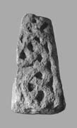
Object type: Part of cross-shaft
Measurements: H. 35 cm (13.8 in); W. 29 > 24.5 cm (11.4 > 9.6 in); D. (max.) 13 < 19 cm (5.1 < 7.4 in)
Stone type: Very pale orange (10YR 8/2) poorly sorted, matrix-supported, shelly oolite. Most of the ooliths have fallen out to give an 'aero-chocolate' texture. The ooliths range from 0.3 to 0.7 mm, but are mostly between 0.4 and 0.5 mm. Elongate shells up to 10 mm across are present. Shells, matrix and ooliths occur in roughly equal proportions. Taynton Limestone Formation?, Great Oolite Group, Jurassic.
Plate numbers in printed volume: Ills. 434-6
Corpus volume reference: Vol 10 p. 246-7
(There may be more views or larger images available for this item. Click on the thumbnail image to view.)
Part of a cross-shaft, broken down the middle of the shaft with carving on face A and the remains of faces B and D. The shaft has wide edge mouldings, and the background to the carving is cut back by c. 1 cm (0.4 in).
A (broad): The face carries one whole spiral volute and the remains of two more from a plant-scroll. Diagonal strands cross at the centre of the volute and loop back around the lower half of the spiral rather in the manner of a ring-knot (see Cramp 1991, fig. 19: encircled pattern C).
B (narrow): Broken vertically. Less than half of the carved surface survives. The carving is very worn but seems to consists of three volutes of a narrow plant-scroll constrained between the corner moulding and a narrow vertical moulding on the right. The right-hand moulding seems to bend a little to the right just above the centre point of the lower volute. The volutes themselves diminish in size as they rise up the shaft. The upper volute appears to terminate in a tightly spiralling boss. The centres of the other two volutes are too damaged to show any detail.
C (broad): Destroyed
D (narrow): This face is also broken in half vertically, probably quite close to the centre line of the carving, and carries the remains of a rather loose interlace which incorporates looped strands that are similar to those on face A.
The plant-scroll on face A is well carved and carefully conceived. The crossing-strands and loops suggest that this is a ninth-century shaft, while the triangular leaf that terminates the main volute on face A supports a date within the first quarter of the century. Face B may have been a mirror-image design either side of a vertical central element.
Two documents, probably both to be dated to 999, provide information about the history of South Cerney (Sawyer 1968, nos. 896, 937; Oakeshott 1999; Kelly 2000–1, nos. 128, 129). The estate is reported to have been seized by Ealdorman Ælfric Cild of Mercia (983–5) from a widow named EadflÆd, probably the widow of Ælfric's brother-in-law, Ealdorman Ælfhere of Mercia (956–83). Ælfric was banished after a royal council at nearby Cirencester in 985, and the estate was restored to EadflÆd, who subsequently bequeathed it to King Æthelred II (978–1016); Æthelred in turn gave the estate to the abbey of Abingdon in 999. Abbot Spearhafoc of Abingdon (c. 1047/8–1051) subsequently gave South Cerney to Bishop Stigand of Winchester before he became archbishop of Canterbury; at the time of the Domesday survey, Abingdon claimed the estate but never regained it (Moore 1982, no. 56,2; Kelly 2000–1, clxiv). The bounds of South Cerney in Æthelred's charter of donation to Abingdon include a nunnena pol, a nuns' pool, but the context is unclear.
South Cerney lay in a strategic location, with the Thames frontier between Mercia and Wessex along its southern boundary, and Ermine Street running south-east from Cirencester into Wessex along part of its eastern boundary. It seems likely that Ealdorman Ælfhere had held South Cerney before Ealdorman Ælfric Cild, and it may be that South Cerney had long been a comital estate on the frontier with Wessex. By the late tenth century, South Cerney would have lost its strategic importance.
